
2026
|
Welcome!Open Houses for August-The Little Red Schoolhouse will be open on Saturday, August 1st & Saturday, August 15th from 1-4 pm, weather permitting. The schoolhouse is on West Main Street near North Coles Avenue, Maple Shade. Also, sometimes it is open on other Saturdays as well. Twp. Needs to move fire alarm box-
I been telling the Township Manager and the Twp Committee this for 1.5 years now! 
The Maple Shade Historical Society had a table there. Maple Shade Library Events-Many events, some historical, at the Maple Shade Library. Events Betty Procopio died May 1stobituary She was a member of the Maple Shade Historical Society for many years and the President for over 20 years. She was a good friend of mine and many. Download the video here if you want to- Schoolhouse video MOV or MP4 January 24 1963 Barlow Mansion (Villa Capri) Fire-Download the video (and a lot more) here if you want to- Marie Franzen shared Sally Starr!-Download the video (and a lot more) here if you want to- Marie Franzen shared Maple Shade Cable Co. video courtesy of Jeffrey Nase-Download the video here if you want to- MS Christmas Decorations Maple Shade Cable Co. being connected- Click on image to download a larger one. I went to the BCL and got a copy of the 1979 Progress Cable TV article. 1976 NJ Declaration-
The 1976 signed document will be at the Little Red Schoolhouse. 1976 MS Bicentennial-
The Historical Society was prominent when the township celebrated history!
American Heritage Presidents books-
I purchased the complete set recently used. They were published in 1969. My Grandparents had them and then gave them to our family in the early 1970s. There is much to love about these books. You think people are divided now concerning politics? It is nothing new. In the earlier times it was fair game for the newspapers to demonize a politician, drawn as some kind of gross animal character. The book series ends around John F. Kennedy. These books and other United States of America related books are on a table at the Little Red Schoolhouse for people to look through and read at the schoolhouse throughout this year as we celebrate the 250th anniversary of our country. -Dennis 
From The New Jersey Mirror, Page 2, 1884-07-16. I got this link to the searchable online old newspapers such as the NJ Mirror from the Tabernacle Historical Society website.- https://burlington.historyarchives.online/home Moorestown Library did this first, digitalizing the old Moorestown newspapers, and now this!
I think they will end up doing all the newspapers whoever "they" are.
 From the The New Jersey Mirror And Burlington County Advertiser, Page 3, 1835-01-08. Reuben was a son of Joseph Burrough who donated the Chesterford School. The land would go to a relative- Charles B. Coles' father. Later the Tiver farm then Alden Park. A side note- In the earlier days roads didn't have exact "titles or names" like we use today. If there was a road from say Moorestown to Camden, the people in Camden would call it "the road to Moorestown" and the people in Moorestown might call it "the road to Camden." It reminds me of the "Back to the Future 3" movie with Michael J. Fox- "Do you have a back door?" "Yea, It's in the back." Another note- Where you see "Burrough's Mill" apartments or condos on Church Road in Cherry Hill- The Burrough family had a shorter lived saw mill. They sold timber for building ships. The Grist Mill was there from pre- 1760 until the 1950s when the Alden Park developers (most likely) razed it. The old Market Ferry Road (part of Rose Ave. is about last of it) went over the dam on the Pennsauken Creek for the mill. It is really another study about the saw mill and these new uses of older places for names isn't extremely accurate. Another good find- The New Jersey Mirror And Burlington County Advertiser, Page 4, 1855-02-22 That blacksmith shop was started in 1847. Christian Frech bought it in I believe 1871. That two story house was last Charlie Brown's restaurant and has been razed several years ago. It might not have looked too nice but it was in about the top 3 historical houses on Main Street! It was the Maple Shade Post Office in Mennel's Dry Goods store. Little Red Schoolhouse attenders-I am putting together some information on some of the farms that were perhaps not covered or covered well in any of my books. I'll be adding more.
Hintermeier Search
The Train Station ConditionThe train station is a historical building not only because it is a train station but because our town was named after it. The Railroad named that Maple Shade first. We need to preserve the insides. The exterior needs a painting with an oil based primer to begin with. For years it has needed painting. -Dennis Weaver NJ and other states going to soon begin teaching cursive handwriting again in the schools!I think we should all start using handwriting again. Here is a super cool envelope of, Iam pretty sure, an invitation from Cropwell Meeting House Friends to their 200th Anniversary. Joe Laufer was the speaker under a big tent with about 200 guests. He mentioned my Burrough family research. Coles Roberts made his home-made ice cream. Betty Procopio was there sitting with me in the back. FancyEnvelope.jpg NJ Coppers-

Two of the three NJ Coppers (replicas) I own, scanned on a scanner. Click on the images for a color corrected image showing more of a copper color. Holiday Reflections-I have a very good memory for a lot of things. The first several years that I went to school we had two President's birthdays off in February. Lincoln's birthday and Washington's birthday. I just looked online at old newspapers and banks even observed each holiday and were closed. Each year at school we would hear the Lincoln and Washington stories as well. I cannot tell a lie father. I chopped down the cherry tree.- Washington. And Lincoln walking back all those miles to return a few pennies or a nickel or whatever. I remember standing in the kitchen at our house on South Church Street, Moorestown, near the refridgerator, (I remember because this was important stuff!) and my Mom told me that there was now only going to be one holiday and one day off from school and they were calling it "President's Day." The news brought a sadness that day. I just wonder now if all the Presidents get lumped into the schools talks around this time of year. For many years, according to former teacher Betty Procopio, grade school classes had to have portaits in their classes of Lincoln and Washington. And this went back into the 1800s I am pretty sure. I believe if we broaden it to All the Presidents then historical meaning is lost as Washington and Lincoln were involved in major wars, the War of Independence and the Civil War. -Dennis News from Den-New Jersey schools are bringing back cursive writing instruction, following Governor Phil Murphy signing a new state law (S1783/A3865) as one of his final acts in January 2026, mandating its teaching to help students read historical documents, sign papers, and develop cognitive and motor skills, reversing the trend that began with Common Core standards. The law takes effect immediately and will apply starting the next full school year, ensuring students can read cursive and write legibly. This is fantastic! I even published a book using for the font a script one- Pioneer Families Houses book For the first 2 hours no visitors at the schoolhouse on an Open House day. To pass the time wisely I read a "McGuffey's First Eclectic Reader" from the late 1800s (reprint) The book was in print writing and the students were to write on their slates in script. The impression I got from all this is that perhaps what we call "printing" was the text used in printed books and newspapers and ALL other writing was done in script. -Dennis 2026!2026 is the 250th anniversary of our country. Here is one of the Maple Shade Historical Society's associations Woodland Farm Also in the 100 year catagory we have Mill Road School was started to be built in 1926 and was ready to open for the 1927 school year. The Benjamin Franklin Bridge, then the Delaware River Bridge, opened in 1926.It was the largest suspension bridge in the world. Thomas J.S. Barlow Sr. was on the Bridge and Tunnel Commission. 1929 Sanborn Insurance Maps released-The 1929 Sanborns (in color) of Maple Shade and Moorestown (With Lenola) are available now. The 95 year copyright expired for some Sanborn maps, not just Betty Boop.
Maple Shade-
Moorestown (with Lenola)- -den Update Info-I was at the second Burlington County History Roundtable meeting on October 3rd at the Burlington County Library. I went to the first one previously. It is a meeting of all the Burlington County Historical Society leaders to discuss their activities and plans. Besides learning what is going on, the meeting also serves to help, inspire and encourage each other. In all my "history of Chester Township" reports, whether on this website or in my books, I have an error- I did not list Riverside as once being a part of Chester Township. I will fix this at my website but probably not in my past published books. Update fixed it on my "Chester Township" page.
Months ago I bought off Ebay four old Lenola photos and have yet to scan them and put them up at my Lenola page. I'll get to that this coming week.
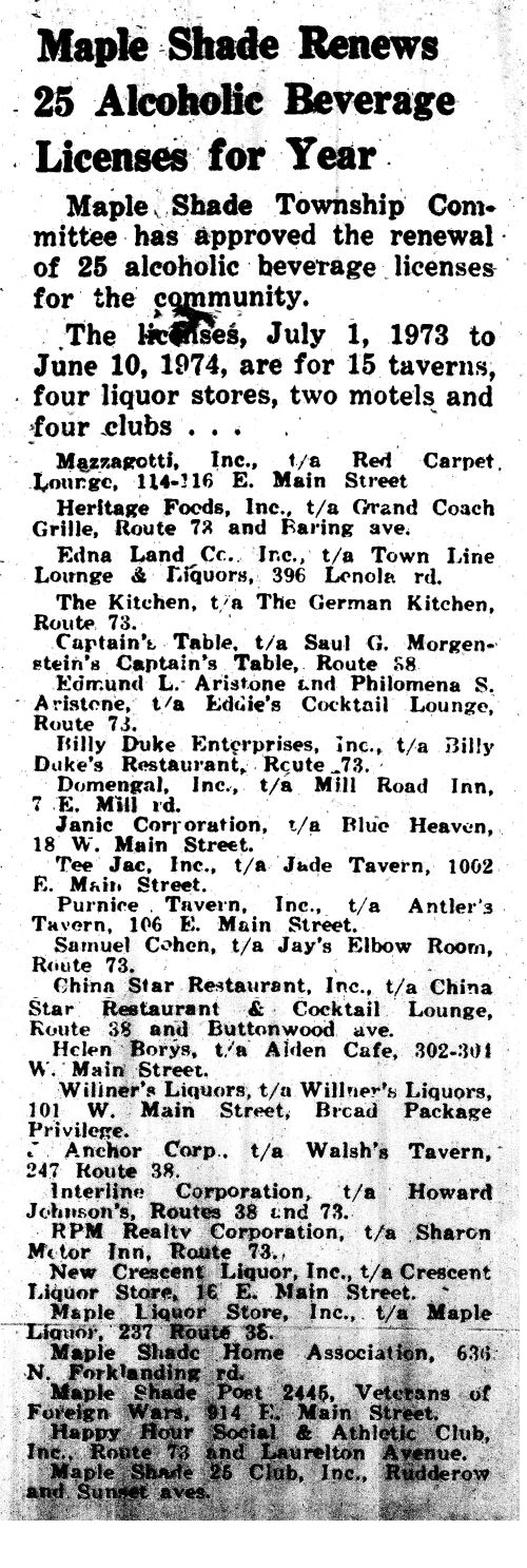
-Dennis Weaver Maple Heights in 1921-Fullpage newspaper sized pamphlet detail scans. Beautiful Maple Heights This was just donated to the Maple Shade Historical Society by Frank Plumber of Texas. Thanks Frank! Books for Sale-I ordered 100 copies of the Little Red Schoolhouse and Maple Shade Historical Society book and will bring copies and sell them at Open Houses at the Schoolhouse. They cost me 6 dollars each by a bulk discount and combined shipping. The printing came out real nice. Your cost- 8-10 dollars (All money above the 6 dollars I paid goes to the MSHS.) -Dennis Weaver Maple Shade Brickyards-I went to the Maple Shade Township Committee meeting to bring up ideas- June 26 meeting Look at about the 48 minute mark for me. I made a PDF version (not exact but very close) of my Maple Shade Brickyard Deed History page at this website. I will probably combine that with the pages in the "Maple Shade, We Celebrate 100 Years" book and other newspaper articles I have also found over the years to make a book about the brickyards. Here is the PDF- Brickyards/MS Brickyards Deeds.pdf Updated Municipal Building site page-A blessing to me was to find that the Philadelphia location of E.W. Twitchell was the building I worked at in the mid 1980s! Immanuel Baptist Church-I just fixed the link. It wasn't working. I guess nobody contacted me because it just said "The Oldest Church."
Oldest Church Building in MS Honoring Maple Shade's Brickyards-GrahamBrickdestroyed.jpg One year after the last brickyard closed in 1956 the Twp. started destroying what was left. I always thought it would be so great if the old kilns etc. were left as an historic site. We do have part of the clay pits undeveloped east of North Pine Ave. and south of the RR tracks. A few years back it was for sale and I'd hate to see it developed and will propose to the Twp. to have it Open Space as undeveloped land for a memorial. The brickyards were formally in MS from 1858 to 1956. Another thing is the John Muffet and Son Brick and Tileyard house built in 1863 now 119 East Main Street. A business is now there which zoning wise it is best not to allow commercial use for a property with historic buildings on it. Perhaps a marker sign could be placed along the sidewalk to honor the house and persaude its current owners to respect it. I have a few articles about the brickyard house over the years. There was a fire in the back that damaged the upper floors when Mr. and Mrs. Senior lived there. They were in bed sleeping at the time. A good article I have to find where I put it- John Pardee was living at the house and was going to sell it. The buyers wanted to tear out all the downstairs walls and make a big room I think for dancing and sell beer and for it to be a roadhouse and the Twp. said no. Transportation to Work in 1924-Many used the trolley to go to work in Camden Hours People Worked in Different Times-My Grandpop was born in 1902 in Philadelphia. He said his parents worked 10-12 hours a day (Mostly 10 hour days), six days a week. He quit school in the 6th grade to work in the factories and later on the ice wagon. Longer work hours and child labor were common in this time period. The Old Shade-What someone told me Maple Shade was like when he was a kid- All the bars up Main Street would have live orchestras and bands playing at them. It was like New Orleans. There were woods in a lot of places all over town. The kids would take wooden boxes and make scooters out of them. When all the kids got together it was like "Our Gang." My friend John Flack's Maple Shade Flicker photos-Brickyard Page fixed-
I have been going over the Maple Shade Brickyards page. Much of it was from around 2005 so there was facts to fix, links to repair or eliminate etc. Making a better version in PDF form and most likely a book which will be about the brickyards or have a full chapter on them.
 Detail from a J.D. Scott's 1876 Burlington County Atlas, colorized- Princeton University- Burlington County, NJ maps)  From a book written in 1877- The History of New Jersey From Its Earliest Settlement to the Present Time · Volume 1 Benjamin Stiles moved from the Old Place of the Stiles which was at the end of Stiles Avenue, then a lane to the house, to the corner of what would soon be in 1850 the "Moorestown and Camden Turnpike" and Fellowship Road. Across the road from his farm was one of the two tollgate houses. The other on what is now Federal Street in Camden. He had a blacksmith shop and house on the property which went through several owners until Christian Frech bought it in 1871. There were other Stiles family farms in the area as well. When the railroad purchased the land at Forklanding Road in 1869 the station was named Stiles Station. The hamlet started to be called just that or "Stiles." The railroad company renamed the station "Maple Shade" in 1874. Charles Shuster began the development of Maple Shade with the "Shuster Tract" in 1887 dividing into lots the old Benjamin Stiles (then son Benjamin J. Stiles) farm which went out to the train station, exempting out the lots of the tollgate house and Christian Frech's and Johnathan Winter's land. (Houses between Spruce and S. Maple Avenues on Main Street plus bank land on other side of Spruce.) Soon other German people, primarily related to Christian Frech's wife Louisa Fahr, came to live on lots. Now we are in the Village of Maple Shade time... Maple Shade in the 30s and 40s movie-That is what we have been calling the movies ran by the Maple Shade Cable Company in probably the 1980s and it is one of the most watched videos at my Youtube channel. It looks like it is really "Maple Shade in 1941." 1941 newspaper articles and the movie as a MP4 At a March or month's prior 1997 Women's Club Meeting, Joe Johnson of the Maple Shade Fire Dept. presented pictures and a film entitled "Maple Shade As It Was." Hmm. wonder if he was showing the same movie. Main Street and Forklanding Road, guessing late 30s to 40sThanks George Conley for the image. Stores in 1933- From the Courier Post newspaper, Sept. 6, 1933 Thanks George Conley for the image. |


Article from the Moorestown Republican newspaper October 21, 1908
Senator Robbins visits Maple Shade. (Headline cut off of scan) Eugene Hill was on the Chester Twp. committee which was mostly of Moorestown people and met in Moorestown. The old Moorestown and Camden Turnpike was discontinued in 1907 when bought by the County.
I saw a old photo of the Roberts monument on its 1/8 acre lot with level ground with grass surrounded by a wrought iron fence.
The South side of Main Street down to about Givnish Funeral Home is higher that the north side of Main Street so originally there was a slope there where Main Street is cut out of the side of the hill.
Everyone knows the gun club is up on a hill and the Roberts monument is up on a hill, but look they're at the same height as the VFW.
The parking lot for Givnish Funeral Home has been somewhat flattened out compared to when the American Legion was on that corner with its uphill yard with two cannons on it.
Let's look at the area where the Roberts family bought a 1/8 acre lot across from the brickyard house on John Mason's farm. The brickhouse is like 2 feet below street grade on the north side of Main Street.
I don't bike up the hill into Maple Shade from Moorestown. It was hard when I was a kid but at least then I could make it. That was referred to as "brickyard hill" for a while in the past. I saw at least one newspaper article where they said pranksters greased the trolley tracks up brickyard hill and then the trolley slipped and couldn't make it up the hill.
Now picture the land was grooved out in the side of the hill when they put Main Street in. (The Market road was laid out as a straight line from Moore's Town to Cooper's Ferry in 1794.) We do not know all of the geometry of the land due to the brickyard which owned the land on both sides of Main Street which it bought from Joseph Walton (Cabinet maker) who's brother-in-law Thomas Lippincott (A Roberts) was a brickmaker. The brickyard had to have removed much clay from the land then the highway did more. But the top of the ridge looks closer to Main Street perhaps than from the top of it all on South Pine Street where the old farmhouse of the Roberts was.
It was a ridge so John Mason's farm on a 1877 Hopkins map is called "Pleasant Ridge Farm."
-Den

Here is quoted from Asa Matlack Sr.'s notes on Colestown-

To get out of the cities part of the year many people had summer cottages. Most of Maple Shade's Barlow Built Bungalows were mostly built in 1922, 1923, and some in the following few years. I do not know how many were used as summer cottages. I would imagine there was a time during the One Acre farm years there were many "shacks" first used before a bungalow was built.
Summer cottages were anything from a shack to a mansion. I couldn't find it last time I looked but I remember seeing in a Camden newspaper that Alexander Mecray was staying at his summer house in Maple Shade. My one grandmother was from "money." (They didn't do the dishes. The help did them. They had a car when hardly anyone else did. etc.) I saw an old photo of her as a kid on the porch of a bungalow in Pennsauken. I said Grandmom I thought you said you were rich. That bungalow looks like mine. She said I didn't understand. That was her Aunt's summer cottage house who lived in Philadelphia. I have a few photos from my other grandparents of a house they built in Cinnaminson in the early 1920s which sat on a few cinder blocks at each corner and clearly had many building issues which would not pass inspection today!
I saw a few mentions of summer cottages in Maple Shade in newspapers. I did oral history of the east Moorestown area and the Miller family would come in the summers and had a shack with bunk beds and would drink beer and the kids soda and they would stake out the area where their "dream house" would be built.
Another topic- There is also Camden's industry which helped early Maple Shade's population to be addressed.
Some selected passages at den's Google Drive
We learn many things from these school reports. We learn that the front small room at the Little Red Schoolhouse was a coat room. (Then called a cloak room)
Coat rooms, no out houses and ventilation were several issues in the 1800s.
Another "conclusion" people would have is debunked. It has in the roots truth but when we see blacks attending school with whites in the late 1800s photos one would "conclude" that this was due to many Quakers in the area and also several teachers known to be Quakers so that is the reason. Wrong. It was the law. When the school was in the Township of Chester tax district after 1894 Moorestown was also in Chester Twp. and had a "Colored School."
It was considered honorable for a town to have a colored school and even Quakers thought so. That law was actually brought up later many years later in a court case which ended segregation. one source
Also in records is the people in each school's tax district starting in 1871 after the Free School law (Public School system). I got the 1873 list from the 1873 Chester Township Tax Assessor's book which years ago was at Moorestown Library. When I was at NJ State Archives in Trenton I read the list of the books they have on microfilm and that was one of the few books they were missing and I told them it was at Moorestown Library and the lady didn't look happy at all with that.
Mark K. Lewis at Phil's Camden website
A plaque for an addition to the school that was on North Poplar Ave. has in the center- Mark K. Lewis.
I already knew of this name due to many of one lot of the first year of the Maple Shade Progress said Mark K. Lewis on them in hand writing. The other half had copies with Theodore Sauselein written on them. There was even mentions of Mark K. Lewis in a copy or two. But this must be for the father- The newspapers are from 1916 and 1917.
They have been published in "The Progress of Maple Shade" book.
It's the son who was killed.
This letterhead or billhead paper is in an old MS Fire Company Treasurer's book. This is the early Barlow & Co. pre Barlow Building and Barlow Built Bungalows. Most all of the tracts listed are not owned by the Barlow family.-
Barlow/BarlowCoEarly.jpg
600 DPI version- Early Barlow & Co. Letterhead
Historical Society member Mike Geden (who is also in the VFW) had his old dog tags from the Air Force returned to him. Someone found them at the beach with a metal detector and mailed them to him.
When you are on Frederick or Thomas Ave. and at the point where they curve at an angle toward Center Ave., you are entering the "Orchards Extension." When you are on South Forklanding Rd. between Crawford Ave. and Mill Rd. you are on what was referred to as "New Forklanding Road" and Crawford "Old Forklanding Road" as Crawford Avenue was S. Forklanding Road on the Shuster Tract until the plan of the "Shuster Extension."


A referendum election which has been called for April 25, at which time the voters of Moorestown, Lenola and Stanwick will decide whether they will secede from old Chester township and form "Moorestown township." If the voters decide in favor of secession, Maple Shade will be the only town left in Chester township. The legislature passed a law giving Moorestown, Lenola and Stanwick the right to call a referendum to decide on forming a new township.
The action of the legislature was greatly opposed by residents of Maple Shade, but they have not requested the right to participate in the impending election, because it appears that voters are somewhat divided on the proposed change. Thomas J.S. Barlow, one of the founders of Maple Shade, says that the town might have a hard struggle at first but must face the inevitable. The town is developing at a rapid pace. an evidence of which is the fact that more than 100 new houses will be erected in the town this year. Many persons feel certain that the town will become self-supporting quite rapidly.
From the Camden Post Telegram, Friday December 1, 1922-
Maple Shade-
Oscar Anderson, local contractor for Barlow and Company, Inc., has completed the erection of 74 houses here and has the contracts for 100 additional ones to be built in the spring.


Really great photos Historical of area towns including Maple Shade.
Compare Maple Shade esp. to 1930 and see how early we turned mostly suburban! Be sure to think of the land area sizes of each of the Twps. as well!
