Detail from 1860 Lake and Beers map.
Moorestown will mention a toll house that was at Lenola and one at the "Forks in the Road." These are added toll houses such as our Coles Avenue one. Originally there was two toll houses with pikes. One was nearby Fellowship Road, the other somewhere about in Merchantville.
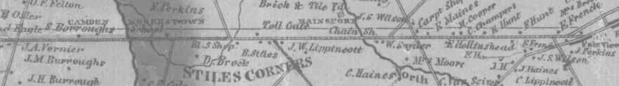
Benjamin Stiles, since the 1844 farmer's meeting of the Turnpike's beginning, was involved in its work. The toll house near Fellowship Road was one of the most important and contributed to the area becoming the hamlet of Stiles Corners, a name which stuck into the coming of the railroad, with the station then being named "Stiles Station."
Benjamin Stiles moved from the "Old Place of the Stiles" to the junction of the Turnpike and Fellowship Road, close to the toll house. His son-in-law was contracted for work on the Turnpike. There is a receipt for a later period graveling of the road payed to his son-in-law Thomas Wilson, in the Camden County Historical Society's holdings.
The Connected route of what is now Marne Highway from Mount Holly to Moorestown's Main Street was actually a separate turnpike called the Moorestown Mount Holly Turnpike. So take the below article with a grain of salt when it starts into saying Moorestown's Main Street was a portion.
There were many turnpikes, five connecting into Camden in 1849. Our 1794 Main Street and the road from Moorestown to Mount Holly weren't turnpikes until the mid 1800s "Turnpike Movement" began. They were "stage roads." The turnpike movement was the answer at the time to improving the condition of the main roads which was previously very poor.
The Moorestown and Camden Turnpike 1851- 1897 Shareholder's Book, which might be the book mentioned in the below article, is now at the Camden County Historical Society (MSS 986, kept in the basement).
Below is an article from The News Chronicle of February 23, 1967-
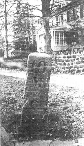 10 Miles To Camden: The old granite marker on Main street opposite Mt. Laurel road is one of the few traces left of the Moorestown Camden Turnpike. 1850 to 1913. |
Connected Moorestown, Camden:Old Turnpike RememberedLittle remains of the old Moorestown Camden Turnpike but several markers and a house opposite the Catholic cemetery on Camden avenue which reportedly, was one of its toll houses. One of the markers can be found on Main street opposite Mt. Laurel road marked "10 M to C" or ten miles to Camden; another can be found at the fork of the road at Camden and Kings Highway in Moorestown. Mayor Charles L. Walton said when he moved to Hartford road, one marked "12 miles to Camden" was found lying in the yard. This was given to the Boy Scouts who used it as a mantel piece of the fireplace in the main assembly hall at Camp Lenape. In "Moorestown, Old and New" by James C. Purdy, published in 1886, he writes, "The old Burlington and Salem road-'The King's Highway'- laid out in 1682 occupied in its course through Moorestown nearly the same ground that the Main street now covers. In 1794 the present turnpike from Mount Holly to Camden was laid out." |
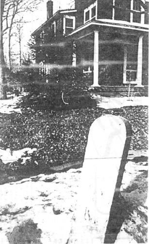 Toll House And Marker: House reputed to be one where tollkeeper for Moorestown, Camden Turnpike, 1850-1913 lived. Opposite the Catholic Cemetery on Camden avenue, it is fronted by a marker, "1 M(Mile) To M(Moorestown)." Photo by Jon Falk |
|
(above article cont'd-) Little seems to be known about the original turnpike other than that the barriers were pikes which turned when the toll was paid hence the name "turnpike." in 1850 a company was formed called the Moorestown Camden Turnpike Company. Stock was sold and the company maintained the road, graveling it when necessary, and generally keeping it in good shape except, perhaps, in the spring of the year. Records show a claim for several hundreds of dollars from a farmer for injuries suffered by himself, his horse, and cart. The claim was settled for $75. Purdy desribes it as follows: "The Main street... section of the turnpike is broad and well kept. On this street are located all the churches save one, both the Friends' meeting houses; nearly all the stores and shops; both the hotels; the Academy, the Bank, the Postoffice, the Town Hall, and the various lodges and society rooms. "But it is not merely a business street; it is one of the principal residence streets of the town... with many beautiful homes... well-shaded dooryards, and in some cases their long stretches of lawn and shrubbery. Norwood Andrews, 77 east Walnut ave, has the records of the turnpike company all beautifully handwritten in leather bound ledgers. His father was the last treasurer of the Moorestown Camden Turnpike. He and his brother, Thomas, have many of the old tickets used, nut none of them carry the amount of the toll. However, Aubrey Walton Sr., Mt. Holly pike, says he used to pay three cents toll from his farm to Moorestown. The turnpike had either five or six tollgates- opinions on this vary. The turnpike company paid collectors $25 a month at the upper gate, middle gate, and lower gate,- the lower gate also had an assistant for $8.50 a month. Andrews thinks they also had their houses furnished. How the tollkeepers were paid at the intervening gates, no one seems to know. John C. Belton,11, 334 Chester avenue, remembers that farmers came from their homes to lift the gate (an arm similar to that used at railroad crossings) and collected the tolls in long handled baskets. Perhaps they recieved a protion of the toll. According to Andrews the turnpike was used commercially, as the townspeople rode to camden on the railroad which was established in 1866 over the protests of conservative residents. The railroad ran its first trian as a special to the Mt. Holly Fair in October of 1867. Purdy says,"It is the highway of the farmers and "truckers" between their homes and the city markets; and in the reoccuring seasons processions of farm wagons or 'shelvings' pass along the street drawn by teams of fine horses that the people here pride themselves upon, and loaded high with hay or straw, or with baskets of glowing fruit and other farm products. "Phaetons, buggies, family carriages, and not infrequently the more conspicuous village cart, and the more elegant private turnout add liveliness to the movement. People in the city have learned that Moorestown is a very pleasant place, and that the road leading to it offers a goodly drive; and in addition to those who make prolonged summer sojourns here, pleasurers drive out on occations. The bicycler has discovered Moorestown also, and besides our own numerous wheelmen, many picturesquely costumed riders from Philadelphia make tours to this place and beyond. "The turnpike offers a capital drive, during a good share of the year, to such as prefer that method of traveling. The road is well kept; it runs through a pleasant country; the surface is varied enough to avoid monotony, and is not so great as to be wearisome, and there "is not much of it taht is not interesting in one way or another." In the later part of 1913 the turnpike was disbanded and the county took over the roads. When The Turnpike Began and Ended- 1849 to 1907The above article states 1850 to 1913. They probably got the 1913 date from a 1914 Roads records book which mentions the Turnpike is now owned by Burlington County, and has no information about it for 1913, 1912, etc..., so they probably assumed it was in the last part of the year and did not make the book. A Maple Shade Historical Society "record" well photo caption has 1909 which could relate to sale of McElwee house perhaps. A few books have the turnpike being incorporated in 1850. Perhaps that is when it was actually finished and operating. ?? Below are infos from the 1849 and 1853 Pamphlet Laws (P.L.), the first having the incorporation act, and the other a supplement, as well as infos from other sources, which are noted below each. —————————————————
The
Moorestown & Camden Turnpike
Charter, P.L. 1849, p. 145
Amendment, P.L. 1853, p. 114
Amendment, P.L. 1855, p. 62
Deed
of Cession, Nov. 2, 1907
Deed
of Cession, Nov. 2, 1907
Note- The incorporation book did not make a mistake in listing two cession deeds of the same date. The turnpike company recorded one cession deed in Burlington County and one in Camden County. Because of their incorporation in New Jersey, the turnpike company filed copies of both deeds with the Secretary of State, hence two Cession listings in the incorporation book. Source:
New
Jersey Secretary of State
1914 Corporations of New Jersey : List of
Certificates to December 21, 1911. MacCrellish & Quigley, State
Printers, Trenton, New Jersey, p. 439.
—————————————————
Burlington County
Moorestown and Camden Turnpike, 3.11 Miles
Long
This turnpike begins at the westerly end of the
village of Moorestown, near the Haddonfield road (now Kings Highway), and extends to the bridge over the west branch of the Pensauken Creek, the Camden county line.
The purchase price was
$22,304.41.
Source:
Hutchinson, E.C.
1908 Fourteenth Annual Report of the Commissioner
of Public Roads For the Year ending October 31, 1907. The John L. Murphy
Company, Printers, Trenton, New Jersey, p. 22.
—————————————————
Camden County
Moorestown and Camden Turnpike
This is the last remaining portion of the old
turnpike into Camden. The section purchased begins at the Camden county line,
up to which point the turnpike had already been purchased by Burlington county
and thrown open to public use, and extends thence westerly to Cooper
river in Camden. The turnpike was purchased subject to the easement of the
trolley over it.
The old pavement consisted of rubble, was very rough
and unpleasant for travel, and the demands of the traveling public had become
so great and insistent that the county could no longer resist the
importunities and therefore asked the State to enter with them in the purchase
of the turnpike and in taking down the toll gates. This is now accomplished
and a free road into Camden from Moorestown is an accomplished fact.
It is the intention of the county during the coming year
to improve this turnpike with a modern form of pavement.
Detailed statement of the cost of the Moorestown and Camden Turnpike
road, townships of Delaware, Pensauken, and borough of Merchantville, county
of Camden.
Total length, 25,689.4 feet, or 4.865 miles.
Kind of pavement,
rubble.
Width of paved way, 18±
feet.
Length of paved way, 25,689.4
feet.
Depth, 6± inches.
Width between slopes or curbs, 38 and 40
feet.
Total cost of road, purchased from Turnpike Co.
for
$22,500.00
Amount allowed by
State 22,500.00
One-third of above, State's
share 7,500.00
We
hereby certify that the above road is finished in all respects in strict
compliance with the plans and specifications.
J.J.
Albertson, Engineer.
Source:
Stevens, E.A.
1914 Twenty-First Annual Report of the
Commissioner of Public Roads For the Year ending October 31, 1914. State
Gazette Publishing Company, Trenton, New Jersey, pp.
26-27.
| ||
Upon looking at a whole series of articles in Mount Holly newspaper microfilm about Moorestown debating in 1918 over putting in a second trolley track due to it disrupting traffic etc..., I questioned if Maple Shade had two trolley tracks at that point.
The Camden & Suburban Railway extended its streetcar (trolley) rails between Merchantville and Moorestown in 1901, it laid two sets of tracks, one on each outside edge of the turnpike. This provided the company with the opportunity to operate their cars at speed unimpeded by farm wagons and other traffic on the toll road.
The double track ended when construction crews reached the intersection of Camden Avenue and Main Street in the village of Moorestown, where local officials forced the trolley company to construct just a single track down the middle of the street instead of two along the side. At Chester Avenue it resumed two tracks. Their line went to Borton Landing Road, Moorestown. The right-of-way remained as built for the line's entire existence with trolley service ending in 1928.
The Burlington County Traction Co.'s trolley line went from Borton Landing Road in Moorestown to Mount Holly. Its formal opening was on May 5, 1904.
The Camden & Suburban Railway and Burlington County Traction Co. "merged" when bought by the Public Service Co. The trolleys were discontinued with the use of buses.
The tracks going to a single track in Moorestown can also be seen in old postcards.