The Custard Stand lot
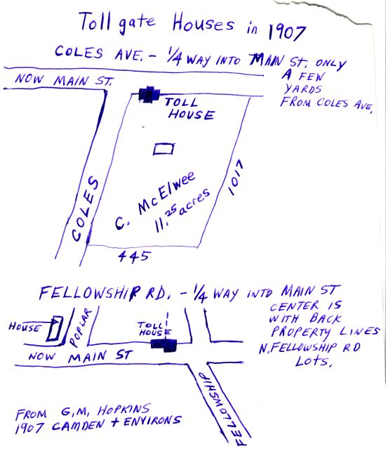
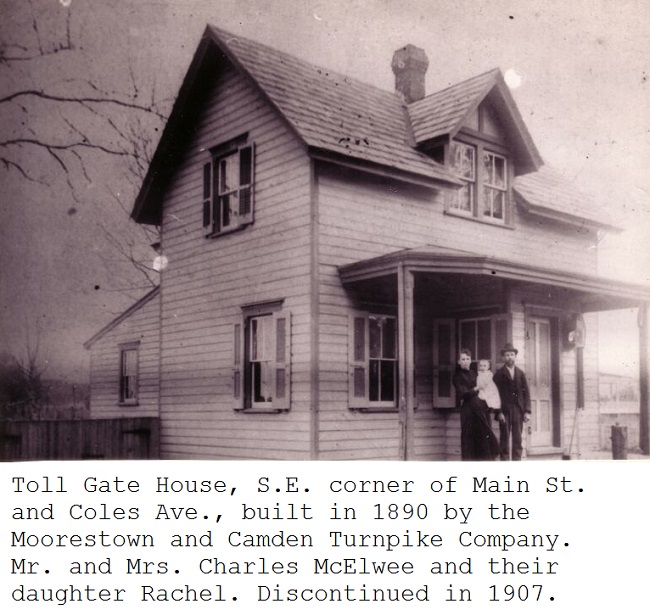
That is the lot where the second toll gate house was built in Maple Shade. (The first one was on East Main Street near Fellowship Road.) It was built in the summer of 1890.
Refer to the court case against the Turnpike Company by Nathan Perkins.
It was used for a toll house from late 1890 until 1907 when the Moorestown and Camden Turnpike ceased.
From a 1900 Hauck's Excelsior Directory-

In the 1907 Chronicle Directory of Moorestown, Charles McElwee is listed as a farmer.
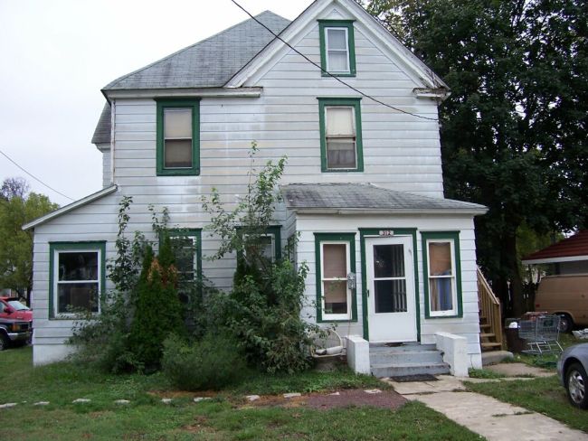
312 West Main Street in 2005
At some point after 1907 the McElwee family moved into a house they had built next door, now 312 West Main Street next to the Custard Stand. It originally had a porch which wrapped around the house. The toll gate house was then used as a store.
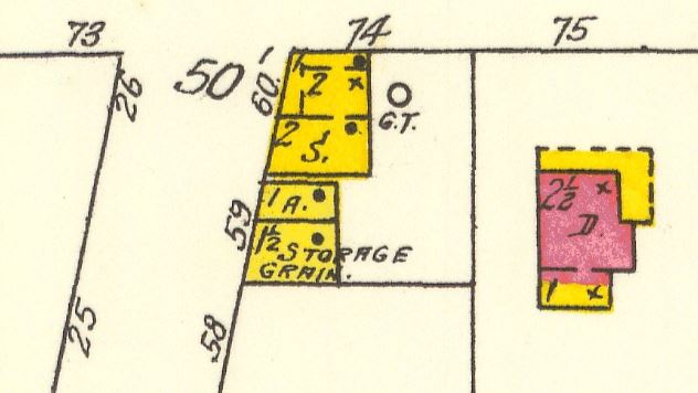
1923 Sanborn map showing 312 West Main Street with wrap around front porch and the toll gate house being used as a store and having a gas pump.
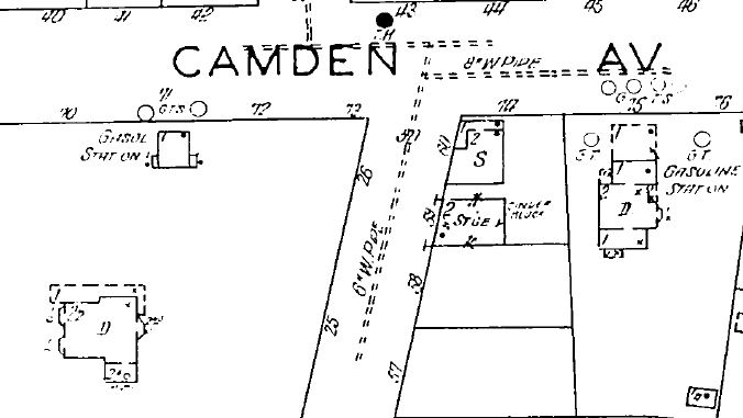
1929 Sanborn map showing 312 as a gas station, the toll gate house as a store, and a gas station on Main St., west of Coles Ave. I do not believe the McElwees had a gas station and think Thomas Murphy owned it at this time. I did not do a title search. Frank Brooks' wife Emma was a McElwee.
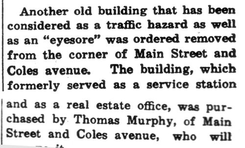
From the Maple Shade Progress newspaper, May 13, 1938. The Twp. was in a "tear down" phase that year. Also in the article
"to go" was the house which stood in front of the Water Works. I think the key words "old building" definately means it was the toll gate house.
I assumed the article was saying Thomas Murphy bought the lot as we know happened. Then I found that that didn't occur until 1940. The print out is cut off and might say that he "bought just the house to move it somewhere."
Stop, Let's rethink all that because of the article below. He bought the gas station on Main Street West of Coles Ave., and then moved it to the toll house/ Custard stand lot. As for the old toll gate house, I do not know what happened to it.
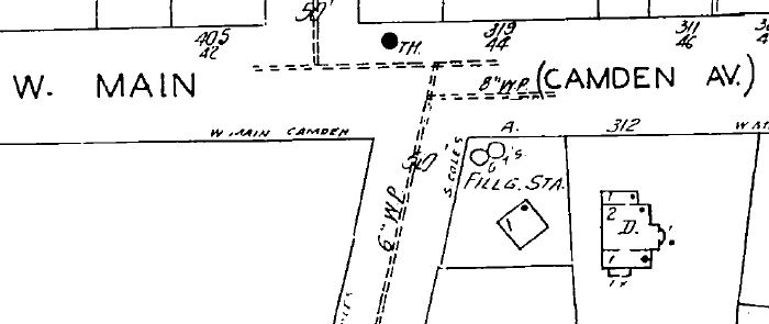
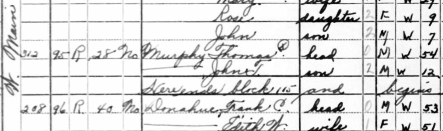
1944 Sanborn map showing Thomas Murphy moved his gas station from 312 West Main St. to the corner. Here is the 1940 Census showing that Thomas Murphy lived at 312 West Main St.-
Below is an article from the Maple Shade Progress newspaper, date unknown-
New Station For 10th Anniversary
Thomas Murphy To Open New Service Station At Main St. and Coles Ave.
Celebrating his tenth anniversary as a Maple Shade businessman, Thomas Murphy, of Main Street and Coles avenue, will open a new gasoline service station at the southeast corner of Main Street and Coles avenue on Monday. The new station, modern in every detail, is adjacent to Murphy's other station and is known as Murphy's Service Station.
The new station will be the only station to handle the Pilot Gasoline in this section. Murphy said, as he has exclusive agency here for it.
Murphy purchased the original business of Frank G. Seitz, which was located in the old Betterment Leaque's Community Hall on Main Street just west of Forklanding road.. Later he moved to his present location. Murphy was in the gasoline and oil business in Philadelphia before he came to Maple Shade.
The new station is modern in all respects and includes modern computing pumps, sanitary rest rooms and display cases for accessories. The building was purchased from the township and formerly stood on the opposite corner in front of the Italian Social Club. Murphy has moved the building and has completely renovated it.
Murphy is also owner of the Rancocas Oil Company, which deals in wholesale kerosene and fuel oil as well as being the sponsor for the Pilot Brand of gasoline.
"No other gasoline sold at the prices of Pilot gasoline," Murphy said today, "can meet its high standard of quality. During our anniversary week all accessories, tires, tubes and batteries will be sold at special prices. Residents of Maple Shade are invited to inspect the new station without obligation," he said.
"I want to express my thanks and appreciaciation." Murphy continued, "for the support I have received during the past ten years from friends and customers. It is through their cooperation that my new station is possible. I pledge the same courteous service as in former years."
Here is a video showing Murphy's Service Station-
In MS in the 30s & 40s movie
Thomas Murphy and his son John changed their gas station into a custard stand in 1953.
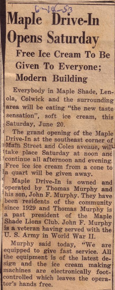
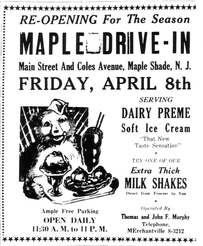
It was officially called the "Maple Drive In"
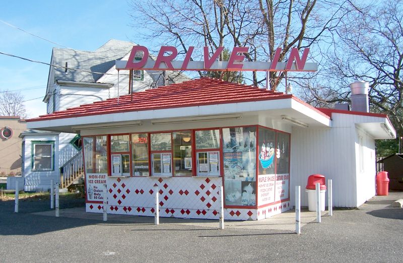
The "Custard Stand" in December 2006
Title Chain for the Toll Gate House/ Custard Stand lot-
Thomas Murphy, of Coles Avenue and Main Street, Maple Shade
took title on July 13, 1940
under deed book 923, page 440
from the Merchantville Building & Loan Association, located and doing business in the Borough of Merchantville
for the sum of Four Hundred Dollars
All the following tract or parcel of land and premises herein after particularly described, situate, lying and being in the Borough of Maple Shade, in the County of Burlington and State of New Jersey,
BEGINNING at a stone corner to land formerly of Levi L. Lippincott, and extending thence (1) South eighty eight degrees and thirty minutes West, 100 feet to a stake corner to same in the middle of the public road, formerly called Mill Road, now called Coles avenue; thence (2) along the middle of the said road, and crossing the Turnpike Road, North twelve degrees East, 152 feet and six inches to a point corner to land formerly of Nathan Perkins; thence by the same (3) South fifty eight degrees and forty minutes East, 75 feet to a corner in the middle of the said Turnpike Road; thence (4) South one degree and thirty minutes East, 107 feet to the place of beginning.
Note from Dennis- The toll gate house was razed or moved in 1938 so it was an empty lot he was buying.
*****
The Merchantville Building & Loan Association
took title on February 4, 1931
under deed book 769, page 267
from Roscoe C. Shinn, Sheriff
for the sum of ONE HUNDRED DOLLARS, being the highest bidder
(Same exact land description as above)
A mortgage was given by
William A. Nilson, and Jessie O. Nilson, his wife
to G. Wilbur Taylor and Estate of George E. Taylor, trading as Taylor Brothers
on January 16, 1926 to October 16, 1930
and not paid so went to Court of Chancery then public auction sale
*****
I missed printing the Willam A. Nilson deed or writing down the book and page number.
There was no Deed Recital section but I took the name to get further back from Grantees index.
*****
William L. Shuster and Mary E. Shuster, his wife of Maple Shade
took title on January 5, 1924
under deed book 627, page 143
from William A. Bougher and Ida May Bougher, his wife
for the sum of FOUR THOUSAND DOLLARS
All that certain lot or parcel of land and premises situate on the South side of the Moorestown and Camden Turnpike Road, at Maple Shade, in the Township of Chester, County of Burlington and State of New Jersey, bounded and described as
follows-
BEGINNING at a stone corner to land formerly of Levi L. Lippincott, and extending thence (1) South eighty eight degrees and thirty minutes West, 100 feet to a stake corner to same in the middle of the public road, formerly called Mill Road, now called Coles avenue; thence (2) along the middle of the said road, and crossing the Turnpike Road, North twelve degrees East, 152 feet and six inches to a point corner to land formerly of Nathan Perkins; thence by the same (3) South fifty eight degrees and forty minutes East, 75 feet to a corner in the middle of the said Turnpike Road; thence (4) South one degree and thirty minutes East, 107 feet to the place of beginning.
*****
William A. Bougher and Ida May Bougher, his wife
took title on December 15, 1921
under deed book 592, page 263
from Joseph Protosewitz and Maggie Protosewitz, his wife
for the sum of ONE DOLLAR
Containing 24 and one half one hundredths of a acre
(This is on this deed and on back, yet the distances are all the same as the above which seems smaller. Oh, it means a quarter acre.)
Note from Dennis- I didn't see Joseph Protosewitz or William A. Bougher on any Census records which might indicate they did not live there but used the building for a business.
*****
Joseph Protosewitz and Maggie Protosewitz, his wife of the Township of Mount Laurel
took title on December 30, 1914
under deed book 512, page 187
from Martha Roberts, Israel Roberts and Horace Roberts,
Executors of Emmor Roberts, and The Moorestown and Camden Turnpike Company
for the sum of SEVEN HUNDRED AND FIFTY DOLLARS
Containing 24 and one half one hundredths of a acre
From Book of Wills 33, page 403-
"Fifth: I hold several lots of land in trust for the Moorestown and Camden Turnpike Company, to wit, one at the Lower Toll Gate, one of eight acres near Merchantville adjoining lands of Joseph H. Amon, one adjoining the residence of Henry B. Coles and one opposite Roman Catholic Graveyard. I desire the said lots or parcels of land to be conveyed to whosoever the directors of the Moorestown and Camden Turnpike Company may direct, and to that end, I do hereby authorize and empower my executors hereafter named, to make and execute all such deeds and assurances as may be necessary in the premises"; and did therein and thereby nominate and appoint his wife, Martha Roberts, and his sons Israel Roberts and Horace Roberts to be the executors thereof.
*****
Emmor Roberts
took title on March 16, 1892
under deed book 298, page 494
from Levi L. Lippincott
for the sum of TWO HUNDRED AND SEVENTY FIVE DOLLARS
Containing 24 and a half hundreth of a acre
Note from Dennis- The toll gate house was built in 1890 on the land. The quarter acre of land is selling for so much because it has a house on it.
*****
Home